Genesis
Legendary Member
- Joined
- Mar 28, 2005
- Messages
- 5,952
- Hatteras Model
- 45' CONVERTIBLE-Series II (1984 - 1992)
Wilma is gonna come knocking, me thinks........
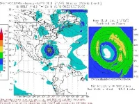
Been watching this thing for a week, and today it finally got the NHC's attention. Some projections on computer models I've seen are VERY bad for intensity (think "Katrina")
Its not quite time to panic yet, but the climatology this time of year says that this storm should come north and EAST, with a potential track anywhere from roughly Cedar Key to the Keys.
I'd pay very, very close attention to this one if you're anywhere from Mobile all the way up the east coast - its possible that it might come through the Keys and up the east coast, although I don't think so given what I'm seeing thus far.
More as my thoughts develop on it.....