Sam's is your source for Hatteras and Cabo Yacht parts.

Enter a part description OR part number to search the Hatteras/Cabo parts catalog:

Email Sam's or call 1-800-678-9230 to order parts.

Inexpensive Handheld GPS with Bahamas and Turks charts ??

  • Thread starter Thread starter ron6785
  • Start date Start date
  • Replies Replies 17
  • Views Views 9,483

ron6785

Well-known member
Joined
Jan 30, 2009
Messages
580
Status
  1. OWNER - I own a Hatteras Yacht
Hatteras Model
53' MOTOR YACHT (1969 - 1988)
Looking for an inexpensive hand held back up to my back up that has charts for not only US coast, lakes and rivers but also Bahamas and Turk etc?? Any suggestions???
 
i havent' found an inexpensive plotter/chart solution for the bahamas, portable or else...

the best set up is OpenCPN with NOAA charts for the US and Arnis NV charts (CD / chart books) for the bahamas. http://www.nv-charts.com/

they run about $80 per region (near bahamas, central, and south) and are very accurate but they have a 3 region special for 149. The charts install easily for use with OpenCPN.

i've used them extensively last winter all the way to Georgetown and was my primary nav system since i didn't have the Cmaps for the furunos.

www.opencpn.org is free (open source) and so are the NOAA charts. it is a very reliable program and works with any inexpensive USB or bluetooth gps. I've used it for the past couple of years now, from Cape Cod all the way to Houston and on many trips to the Bahamas, as reliable and accurate as built in plotters and uses fewer system resources on your computer than commercial software.
 
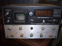
Here's one I used to have on the boat that you can borrow.
 

Attachments

  • PA080012.webp
    PA080012.webp
    22.6 KB · Views: 114
i havent' found an inexpensive plotter/chart solution for the bahamas, portable or else...

the best set up is OpenCPN with NOAA charts for the US and Arnis NV charts (CD / chart books) for the bahamas. http://www.nv-charts.com/

they run about $80 per region (near bahamas, central, and south) and are very accurate but they have a 3 region special for 149. The charts install easily for use with OpenCPN.

i've used them extensively last winter all the way to Georgetown and was my primary nav system since i didn't have the Cmaps for the furunos.

www.opencpn.org is free (open source) and so are the NOAA charts. it is a very reliable program and works with any inexpensive USB or bluetooth gps. I've used it for the past couple of years now, from Cape Cod all the way to Houston and on many trips to the Bahamas, as reliable and accurate as built in plotters and uses fewer system resources on your computer than commercial software.
Thanks, are you running these programs thru your computer. Mine is a Dell and doesn't work at all well in sun light. By the way how far is it (NM) from the Bahamas to Nantucket,isn't that where your boat spends the summers. We'll be working our way up the east coast next spring and the Chesisiwas too hot this past summer. So will have to go farther North.

Thanks for info ,

Ron
 
Here's one I used to have on the boat that you can borrow.
What the H___L is that ?? Looks like you could bake a pie with it.

Ron
 
Its my old Loran A they were about the size of a microwave and it took about 15 min to get a bearing. You had to sit there and line up the signal waves in the crt scope. and then plot them on a loran chart. It was hot snot in 1976. cost us about $2500 in '76 $ was a lot of money. and it didnt work real well after dark because of signal skip. We realy have it pretty good today in terms of nav equipt.
 
Yes mostcomputers are readable in a pilot house. I have an HP notebook/tablet and it s fine on the enclosed flybridge. On an open FB it wouldn't work but as a back up you can leave it in the PH

The boat I run spends the summers in Nantucket. Since the owner doesn't need to take it out, I don't stay up there and fly back home to Miami unless we get a charter. It s about 1600NM from Miami to Nantucket. I m on my way down right now, anchored in Rock creek by baltimore

It s really nice but dockage is sticker shock level... Moorings are the to go if you have an inverter. Water is the issue, you need a water maker (and a lot of filters!) or a 50gal bladder and pump in your tender...
 
That is one big loran... I have never seen one that big. Most LORANs I have seen in my lifetime look more like this:

figure7-1.gif
 
I have to ask why do you wand a cheap hand held?

Is is a back up? One for the ditch bag? I would use an I phone as a "toy" but for backup the idea is to get the best possible.
 
That is one big loran... I have never seen one that big. Most LORANs I have seen in my lifetime look more like this:

figure7-1.gif


That was loran A what you have there is loran C. C became popular in about 1979 and was fully automatic. with the A you had to actualy measure the time delay between tha master and slave stations using a occiliscope type crt tube. It was done in three steps. Basicly you saw the actual signals as sort of a blip and had to move two pedestals to align the blips. The real chalenge was to figure out which blips were skip or noise. once you got one # you had to do it all over again for the second. By then the boat had traveled several miles and the fix would be off. A lot of people would get seasick doing this and the sets were always below because they were'nt weather proof and cost so much.
I learned to work one when I was 12 We had an earlier more complicated one than the one in the pic. My dad didnt have the patience to sit down and figure it out so I did. I was working for a guy that had a 41 washing his boat when he came in. when he found out I could work the loran he started taking me with. I had a lot of goodtimes on that boat I was always treated like one of the guys .
 
Last edited:
That one was a Kelvin Hughes a lot of the electronic co's were Brits then especialy the radars. I had a Decca 110 on the 50 for 20years the magnatron finaly got weak and I had to give up on it. I ve had a bunch of different nav eqipt on the boat. I currently have a garmin 2010c and a 3010c. I have garmin in my plane also but up until Feb also had a northstar loran which in the plane was almost as acurate as the gps. Obama pushed to shut down the Loran network which he did in feb. IMO this was a huge mistake. we now have no land based backup for the GPS system. I was in the Bahamas when the 4096 rollover problem ocurred and my GPS was inop for 2 days.Glad i had the loran. There are all kinds of things that could happen to the sats.
 
That one was a Kelvin Hughes a lot of the electronic co's were Brits then especialy the radars. I had a Decca 110 on the 50 for 20years the magnatron finaly got weak and I had to give up on it. I've had a bunch of different nav eqipt on the boat. I currently have a garmin 2010c and a 3010c. I have garmin in my plane also but up until Feb also had a northstar loran which in the plane was almost as acurate as the gps.

The Brits had a central role in pioneering radar. I looked up Kelvin Hughes and they are a huge company, but it seems like they deal mostly commercial and military type radars.

Obama pushed to shut down the Loran network which he did in feb. IMO this was a huge mistake. we now have no land based backup for the GPS system. I was in the Bahamas when the 4096 rollover problem ocurred and my GPS was inop for 2 days.Glad i had the loran. There are all kinds of things that could happen to the sats.

Ahh, folks should learn (or re-learn) how to navigate by compass and chart. We have drifted away from the virtues of boating. However, chart plotters with colorful 17'' screens are pretty fun to play with when en route.

What really pissed me off was when they shut down analog television and switched it over to digital. Now all I get in my workshop are PBS-type government propaganda stations preaching green living and 'community empowerment'...
 
Yes mostcomputers are readable in a pilot house. I have an HP notebook/tablet and it s fine on the enclosed flybridge. On an open FB it wouldn't work but as a back up you can leave it in the PH

The boat I run spends the summers in Nantucket. Since the owner doesn't need to take it out, I don't stay up there and fly back home to Miami unless we get a charter. It s about 1600NM from Miami to Nantucket. I m on my way down right now, anchored in Rock creek by baltimore

It s really nice but dockage is sticker shock level... Moorings are the to go if you have an inverter. Water is the issue, you need a water maker (and a lot of filters!) or a 50gal bladder and pump in your tender...
Yes, I would stay on the hook or a ball, we make water and have an inverter. Thanks for the info. I was able to pick up a Garmin Colorado handheld with Lakes, rivers, coastal and bahamas/turks for $239.00. I really want to use it with the 17' center consol I use as my dink
 
i havent' found an inexpensive plotter/chart solution for the bahamas, portable or else...

the best set up is OpenCPN with NOAA charts for the US and Arnis NV charts (CD / chart books) for the bahamas. http://www.nv-charts.com/

they run about $80 per region (near bahamas, central, and south) and are very accurate but they have a 3 region special for 149. The charts install easily for use with OpenCPN.

i've used them extensively last winter all the way to Georgetown and was my primary nav system since i didn't have the Cmaps for the furunos.

www.opencpn.org is free (open source) and so are the NOAA charts. it is a very reliable program and works with any inexpensive USB or bluetooth gps. I've used it for the past couple of years now, from Cape Cod all the way to Houston and on many trips to the Bahamas, as reliable and accurate as built in plotters and uses fewer system resources on your computer than commercial software.
Ok I've downloaded open cpn but all I get is an outline of the shoreline and some tools, no charts do I download the chartss after installing the software download??
 
I bought an iPad (great for internet use on the boat) and found a Navionics app for $25 with lifetime updates. The GPS is dead on with amazing detailed charts. The iPad was $630 (you need the one with 3G to get the GPS) which is not cheap but if you can use it for other things it makes an exellent nav unit on your boat. The $25 app includes all the Bahamas and the east coast from Alabama to Canada. I think the charts would be hundreds of dollars if you bought them for a chartplotter.

http://www.navionics.com/MobileMarineCharts.asp?ContinentID=5&MobileType=iPad
 
Ok I've downloaded open cpn but all I get is an outline of the shoreline and some tools, no charts do I download the chartss after installing the software download??

yes, all you need to do is download the free NOAA charts then in OpenCPN, go to tools, charts and select the folder/directory where you copied the chart files.
 
yes, all you need to do is download the free NOAA charts then in OpenCPN, go to tools, charts and select the folder/directory where you copied the chart files.
Thanks pascal, will do tomorrow. I did take a look at NOAA site do I download the ENC charts. Looks like you can download them by state and also Coast Guard Region , am I in the right section?? Thanks for the help. Ron
 

Forum statistics

Threads
38,156
Messages
448,746
Members
12,482
Latest member
UnaVida

Latest Posts

Trending content

Back
Top Bottom