Pete
Legendary Member
- Joined
- Apr 12, 2005
- Messages
- 1,167
- Status
- OWNER - I own a Hatteras Yacht
- Hatteras Model
- 48' LRC (1976 - 1981)
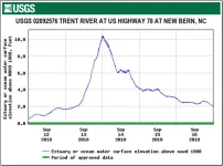
Below is the water height monitor tracking for the time period around the arrival of Florence, as reported by USGS at the Trent River station next to the New Bern Grand Marina.

Just a few words to provide perspective. A rise in this level in the 4 to 6 foot range is BAU for this area. Having lived just down the Neuse for 19 years, hurricanes usually give us 6 to 8 feet, which does produce some flooding and property damage for those in low lying areas. Wind damage is usually a bigger concern than water rise. As a reference the county building code is 8 feet for the first finished floor. The maximum I have personally seen is 8.5 feet.
Net is starting at around 10:00 PM 9/13/18 and continuing for something less that 8 hours, all the flood damage was done in the dark of night with electric power down.

